Contents
Route description
The impressive Maroon Bells
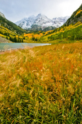
The scenery around the Maroon Bells is reputed to be the most photographed spot in Colorado for a reason: The view to the southwest from the Maroon Creek valley upon the Maroon Bells will be one of the most premier scenic overviews you will ever see. “Maroon Bells” is the name for two peaks in the Elk Mountains of Colorado, the Maroon Peak and the North Maroon Peak. Both peaks are amongst the famous 53 “fourteeners” of Colorado, which means they exceed a height of 14,000 feet. The two peaks are 14,163 feet (Maroon Peak, 4,315 meters) and 14,019 feet (North Maroon Peak, 4,270 meters) high and are located not far from Aspen.
You can start your hike right from the parking area up the trail to Maroon Lake. After a few minutes you will be amazed by a first glimpse at the Maroon Bells already. Even the last bit of doubt why this is such a famous spot will be vanished after you look at the scenery with the Lake in front of you and the mountains right behind. If you turn to your left you will also see Pyramid Peak, yet another fourteener. Meanwhile, hike the trail beside the right side of the lake and then follow the sign that says “Scenic Loop Trail”.
Through the Aspen Forests
Thereupon the hike continues over a little bridge above West Maroon Creek while the path takes a gentle slope upwards. With sturdy shoes the uneven trail should not be a problem at all, even for inexperience hikers. Remain on the trail beside the river and you will get to another bridge that goes over the West Maroon Creek from the right side. However, leave the bridge aside for now and follow the path straight ahead towards the Aspen Forests. The name of the city Aspen actually come from the trees in this area. Advance on the trail that starts departing a little bit from the Creek.
Eventually the Loop Trail takes you back towards Maroon Lake, where you will see the Creek again and cross the bridge that you left aside before. Afterwards simply follow the trail beside the Lake back to the parking area.
Where to eat
There is no possibility to buy food on the hike. However, there are numerous benches on the way that invite you to eat your pick nick while enjoying the magnificent view.
Interesting facts
- You're traveling a distance of 3 km on this easy trail. The hike is therefore not too long. The average length of all hikes in Colorado is 14 km.
- Maroon Lake Scenic Loop Trail is the the best rated hike in the USA.
- Elevated between 2,817 m and 2,985 m, the hike is the highest elevated hikes in the USA. You're facing an uphill climb of 260 vertical meters on this hike.
- The hike is one of the family friendly trails in the region. What’s even better: You can also bring the family’s best friend on this dog friendly hike.
- In case of good weather conditions, the hike can also be done without bringing your hiking boots.
Highlights of the tour
Since the Maroon Bells are one of the most photographed scneries of Colordo for a reason, you should definitely enjoy this sight live. The view from Maroon Lake up onto the peaks is sheer brilliant: Make sure to capture it!
Variations
You can also hike the Loop Trail the other way around. Just cross the second bridge over West Maroon Creek and follow the path to the right.
Getting here
You can get to Aspen while driving on the Interstate 70 and exiting by Glenwood Springs. The State Highway 82 takes you towards Aspen from here. If you are traveling from Denver between the end of May until the beginning of November you can also make use of the Independence Pass to get to Aspen, which offers spectacular sights of the Rocky Mountains on the way. To get to the Pass take Interstate 70 to Vail and change there to the Highway 24. When you get to Leadville, which is the highest incorporated city and the second highest incorporated municipality in the United States, make sure to turn right onto the State Highway 82. The Independence Pass starts from here.
The Maroon Bells Scenic Area will then be located south west of the city. Driving west – just before the city – turn onto Maroon Creek Road in the roundabout. While following the road you will get to a Welcome Station and then to a parking area. Please make sure to note, that there are tolls for using the road, plus it is not allowed to drive here during the daytime between míd June and the end of September. There are shuttle-buses operating from Aspen during that time of the year. They run every twenty to thirty minutes from Rubey Park and Aspen Highlands.
Here is a little hint: Tickets are half-off on Wednesdays!


