Route description
Grouse Grind Trail
Grouse Grind Trail is Canada's most popular hiking trail. To reach the top of the mountain you'll have to manage a challenging hike first. In less than 3km/1.8mi the trail leads over 850m/2789ft upwards.
Route
Start hiking at Grouse Mountain's gondola cableway. We recommend to strech arms and legs before you start the challenging hike. Walk towards the gate and across the small bridge. The constant ascent starts there.
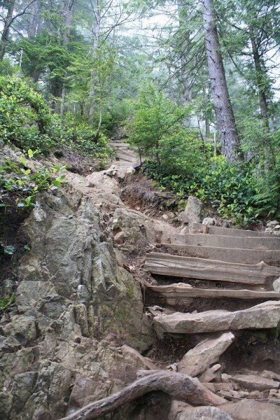
When you reach a junction turn left and continue across rocks, roots and wooden stairs. After approximately 15min you'll get to a little bridge and after another 10min you'll hit the first signpost, which indicates you managed the first quarter. This helps estimating the effort you'll need to complete the whole tour. Don't overestimate yourself, rather turn arround if the tour gets to hard.
Continue ascending on the wooden stairs and if you make it all the way to the top you can be very proud to have defeated the „grind“. At Grouse Mountain Chalet you can buy tickets for the gondola and reward yourself with a cold drink and the beautiful view.
Where to eat
Grouse Mountain Chalet is a good place to get food and drinks, however it is located on top of the mountain, the destination of your tour.
Interesting facts
- You're traveling a distance of 3 km on this strenuous trail. The hike is therefore not too long. Average length of all hikes in British Columbia is 19 km.
- You shouldn’t forget to bring your hiking boots. There are some sections on the trail where sturdy footwear is required.
Video
Highlights of the tour
Nothing for beginners. This tour is even challenging for experienced hikers with good stamina. All the better you will feel once you reached the top.
Equipment
Sturdy shoes are a must, since the trail leads across rocks and roots steeply uphill.
Getting here
By car:
Coming from Vancouver:
Take Georgia Street, drive along Stanley Park Causeway and across Lions Gate Bridge. After crossing the bridge turn right towards North Vancouver and change to the left lane, which leads onto Capilano Road. Continue across Capilano Suspension Bridge and Capilano Dam until you get to the parking right at Grouse Mountain.
Driving on Trans Canada Highway #1, take Iron Workers Memorial Bridge towards North Vancouver and exit at Capilano Road on which you stay until you reach the parking at Grouse Mountain.