Bike Trail From Balzers to Regitzerspitz in Liechtenstein: Position on map

Webcams along the Bike Trail From Balzers to Regitzerspitz

From Balzers to Regitzerspitz
Advertisement
Malbun - Familotel Gorfion
Elevation: 1,620 m
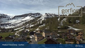
View from the roof of Familoter Gorfion in Malbun.
1 hour ago
Malbun - Liechtenstein
Elevation: 1,544 m
This webcam is located near Malbun in Liechtenstein.
21 minutes ago
Malbun - Hotel Turna
Elevation: 1,611 m
This webcam is located at Hotel Turna in Malbun - Liechtenstein.
22 minutes ago
mountain "Pardiel", Bad Ragaz
Elevation: 1,633 m
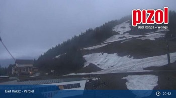
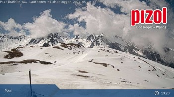
You can see the view from mountain "Pardiel" to the chairlift "Laufböden"
1 hour ago
Laufboeden, Wangs
Elevation: 2,193 m
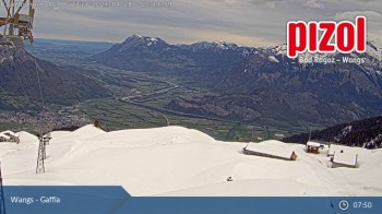
Here you look from mountain station Laufboeden in Wangs to Gaffia-Pizolhuette
1 hour ago
mountain station "Furt", Wangs
Elevation: 1,371 m
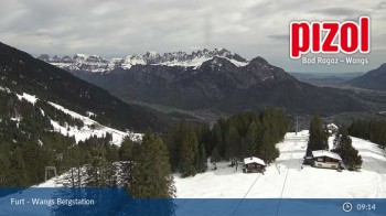
You can see the view from the mountain station of gondola Furt - Wangs
1 hour ago
Laufböden: Bergstation
Elevation: 2,226 m
Bad Ragaz - Laufböden (Ostschweiz / Fürstentum Liechtenstein - St. Gallen)
1 hour ago
"Gaffia" mountain station, Wangs in Eastern Switzerland
Elevation: 1,519 m
Here you look from mountain station "Gaffia" to the valley
1 hour ago

Webcam is Missing

A webcam is missing? Do you know the source of another one?

All Webcams on the map

Webcam Information

  • There are 8 webcams dotted around the Bike Trail From Balzers to Regitzerspitz. The webcams fall into three groups, namely 6 live streaming webcams, one panoramic webcam und one further webcam.
  • The highest webcam (Laufböden: Bergstation) is located at an altitude of 2226 metres, while the lowest one (mountain station "Furt", Wangs) is situated at an altitude of 1371 metres.
  • Most popular and most viewed/visited webcam: Malbun - Liechtenstein.
Travel Deals & Tips
Advertisement
Advertisement
Advertisement
Advertisement
Login with Google+
  • Share your personal insider tip and create new entries
  • Explore fantastic outdoor destinations when and where you want
  • Find your dream destination or discover the world on the interactive map