
Swimming Lake
Surrounded by mountain ranges
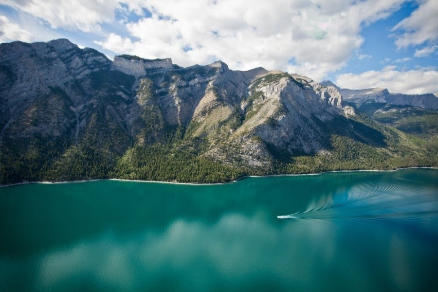
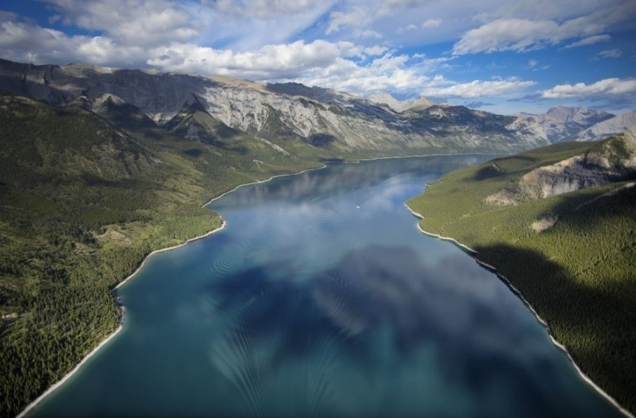
Lake Minnewanka is one of the largest waters in the entire Banff National Park and is also considered one of the most beautiful in the Canadian Rockies. The lake itself is surrounded by a multitude of mountain ranges and thus makes a particularly beautiful picture in the midst of these giants. From these slopes, some streams flow down into the lake, so that Mount Inglismaldie, Mount Girouard and Mount Peechee also ensure that the lake is always supplied with sufficient water. The water is fed centrally by the Cascade River, which is a tributary of the Bow River.
Historic waters
Historically, the lake also has a special significance. Thus, this area was already inhabited by indigenous people more than 10 000 years ago, which archaeologists have been able to prove with several finds such as small stone tools or spearheads. Since its recent days, however, the lake has developed centrally in its position. Besides numerous leisure activities, dams were built on the lake in 1912 and 1941 to supply the nearby town with water power. After the construction of the dam in 1941, the lake's water level rose by a total of 30 m and flooded the recreational resort of Minnewanka Landing, which had existed at that time since 1888.
Things to do
Wide range of products
Although Lake Minnewanka is a mountain lake and is partly fed by the mountain streams of the surrounding mountain ranges, it is mostly used as a bathing lake despite its cold water. Besides swimming, you can also use the lake and its surroundings for hiking, walking, cycling and above all fishing. Furthermore, the flora and fauna around the lake is very diverse, so you can also admire many wild animals and rare species of flowers.
Activities on the water
There are also several guided boat tours on the lake, which are offered in the rules from mid-May to mid-October. During this you will get a lot of entertaining and at the same time informative facts about Lake Minnewanka and you can enjoy the unique view of the Canadian Rockies at the same time. However, if you prefer to explore the surface of the lake on your own, you can also rent motor boats, which are particularly suitable for a fishing trip on the water. There is also the possibility to rent pedal boats for up to 4 persons around the lake.
Interesting facts
- The swimming lake permits to bring a dog along.
- Meals and drinks are provided thanks to a nearby restaurant.
- In case you are into camping, there is a campground almost within reach.
- The nearby parking lot offers enough space for your car. Restrooms for both women and men are available at the Swimming Lake.
Video about Lake Minnewanka Banff
How to get there
By car
From Calgary
From Calgary, follow the Bow Trail west out of the city and turn right at the intersection with the Sarcee Trail. After a short time you change to the Trans-Canada Highway towards Banff and follow it for a total of 110 km until you can take the exit to Banff itself. After the exit, keep left on Banff Avenue and you will arrive directly in the city centre.
From Jasper
If you start your journey from Jasper, you first take Connaught Drive west out of town and change after a short time. Now you cross the Yellowhead Highway and you are on the Icefields Parkway. Follow this for the next 285 km, passing through both Jasper and parts of Banff National Park. At the height of Lake Louise you have to change to the Trans-Canada Highway, from where you take the exit towards Banff a short time later. After that, stay on Mt Norquay Road and then change to Gopher Street, which will take you directly into the centre of Banff.
From Lethbridge
From Lethbridge in the south, you first take the Scenic Drive out of the city and get to the entrance of the Crowsnest Highway (Highway 3), which you follow in the direction of Calgary. After about 18 km you turn slightly right and follow the signs towards Monarch/Vulcan. You will then reach Highway 23, which you follow until you can turn left towards Claresholm. When you arrive in Claresholm itself, turn left and follow the signs towards Calgary/Nanton. In the following you will get on the Queen Elizabeth Highway (Highway 2), which will lead you through Nanton first, so that you will pass Silver Lake and continue driving north. Then keep right to get on the Deerfoottrail, which you leave at the exit Southland Drive in the first foothills of Calgary. Stay on the road of the same name for a short while and then turn right onto the Blackfoot Trail. This will take you to the driveway of the Glenmore Trail, which you follow for about 8 km through the city and then continue on the Sarcee Trail. After that you change to the Trans-Canada Highway in the direction of Banff and finally reach your destination after another 110 kilometres.
Once in Banff, you are now heading for Banff Avenue in the city centre. There is already a particularly picturesque route signposted, which takes you directly to Lake Minnewanka.