
Description
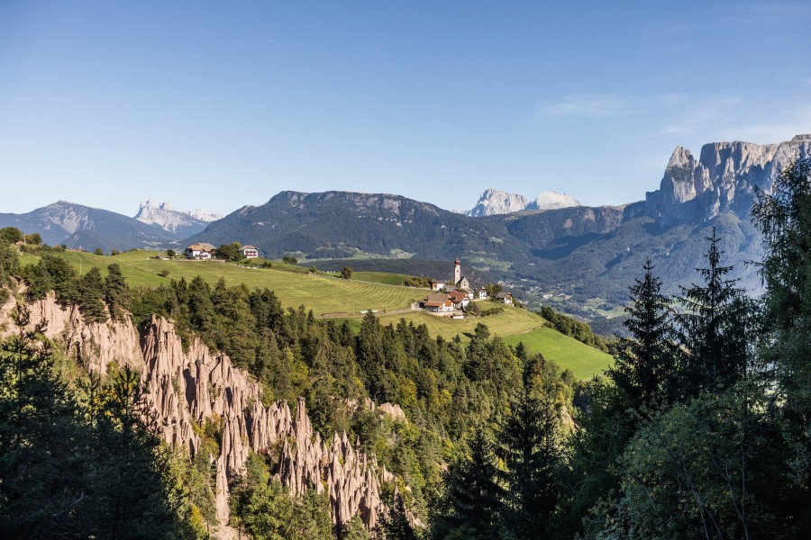
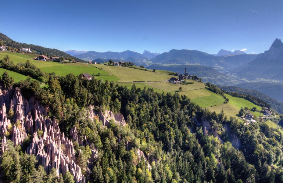
When most people think of South Tyrol, they imagine rolling alpine pastures and the jagged peaks of the Dolomites. But on the Ritten Plateau, nature has carved out something entirely unexpected: towering clay columns that rise dramatically from forested ravines and green slopes – the Earth Pyramids of Ritten. They’re the tallest formations of their kind in Europe and an ever-changing geological spectacle.
You’ll find these majestic formations in three distinct locations between the villages of Lengmoos, Oberbozen, and Unterinn. Each group of pyramids has its own unique character.
Lengmoos (Finsterbach Ditch)
The Earth Pyramids near Lengmoos are the best known and easiest to reach. A wide, barrier-free trail leads from the parking area to an observation platform in just ten minutes. Along the way, panoramic views open up to the striking formations – some soaring more than 30 meters into the air. This spot is perfect for families, photographers, and anyone who wants to admire the pyramids without a strenuous hike.
Oberbozen (Rivellaun Ditch)
Below the village of Oberbozen, another group of pyramids clings to steep ravine walls. They’re slightly more remote, accessible only by foot – but well worth the effort. Along the scenic trail, you’ll glimpse clay spires clustered tightly together, especially magical when viewed in backlight or moody weather. Nature lovers and trail enthusiasts will feel right at home.
Unterinn (Gasterer Ditch)
The third site lies in the Gasterer Ditch near Unterinn. Here, the landscape feels wilder, the terrain more rugged. Getting there requires a bit more stamina, but rewards visitors with unique angles and peaceful surroundings. For those seeking solitude and raw nature, this is the spot to explore.
A Natural Wonder in Transition
The Earth Pyramids are constantly changing. Heavy rainfall can create new spires while others collapse when their protective capstone falls. Visit at different times of year, in changing light, or from various angles – and you’ll discover a new scene every time.
Historical Information
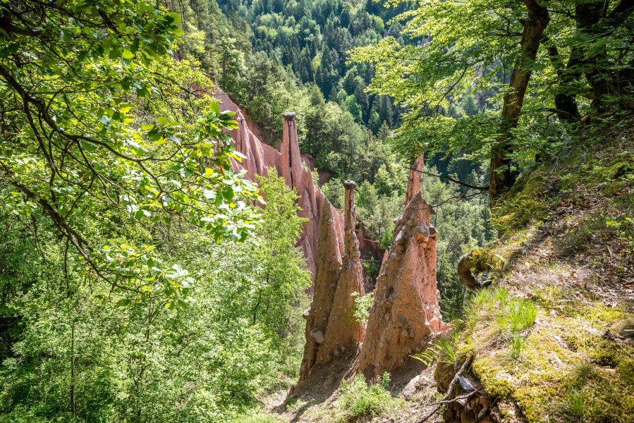
These formations occur in clay-rich moraine soils left behind by glaciers during the last Ice Age. When rain loosens the steep slopes, the clay is gradually washed downhill – except where large boulders sit atop the surface. These stones act as umbrellas, protecting the soil beneath. Over the years, tall pillars of earth rise beneath them, topped by their guardian capstones.
But nothing lasts forever: once a stone falls, erosion sets in and the pyramid slowly shrinks – until it disappears altogether. And somewhere else, a new one begins to grow.
How to get there
The Ritten Plateau rises above the Eisack Valley just northeast of Bolzano and offers stunning views of the surrounding South Tyrolean mountains. Thanks to its great transport links, it’s easy to reach by car or public transport.
By Car
From Bolzano, the well-developed Ritten Road (SP73) winds its way up to the plateau in about 30 minutes. Depending on your destination, it's worth taking the route via Klobenstein, Oberbozen, or Unterinn.
- Lengmoos (Finsterbach Graben): From Bolzano, follow the well-maintained Rittnerstraße (SP73) to Klobenstein, then head to Lengmoos. Parking is available at the start of the panoramic trail – just 10 minutes from the viewpoint.
- Oberbozen (Rivellaun Graben): Also accessible by car, with signposted hiking paths leading to the pyramids.
- Unterinn (Gasterer Graben): The route is more challenging, but reachable from nearby parking areas on foot.
By Public Transport
From Bolzano city center, take the Ritten Cable Car up to Oberbozen in just 12 minutes. At the top, hop aboard the historic Ritten narrow-gauge railway, which departs every 30 minutes toward Klobenstein. From there, it’s a short walk to the Lengmoos site.
You can also take the 165 or 166 regional bus lines, which connect Bolzano with Oberbozen, Klobenstein, and Unterinn. All pyramid locations are clearly signposted and easy to combine with hikes or leisurely loop trails.