Around Me
Search
List
Map
Combined
+
+
Guide
Europe
Germany
Austria
Italy
Switzerland
France
Spain
Greece
Great Britain and Northern Ireland
Czech Republic
Liechtenstein
Iceland
Romania
Belgium
Hungary
Portugal
Slovakia
Ireland
Netherlands
Denmark
Norway
Finland
Malta
Sweden
Slovenia
Lithuania
Serbia
Poland
Ukraine
North America
USA
Canada
Costa Rica
Oceania
New Zealand
Australia
Africa
Egypt
South Africa
Asia
Japan
China
United Arab Emirates
Turkey
India
Azerbaijan
Georgia
Iran
Russia
South America
Brazil
Hiking
Europe
Austria
Germany
Italy
Switzerland
Liechtenstein
France
Belgium
Iceland
Romania
Norway
Ireland
Great Britain and Northern Ireland
Denmark
Sweden
Portugal
Spain
North America
USA
Canada
Oceania
New Zealand
Australia
Biking
Europe
Austria
Germany
Switzerland
Italy
Spain
Liechtenstein
Romania
Finland
France
Great Britain and Northern Ireland
Lithuania
Iceland
Ireland
North America
Canada
USA
Swimming
Europe
Austria
Germany
Switzerland
Italy
Romania
Hungary
Iceland
Spain
Belgium
Slovenia
Ireland
Netherlands
Great Britain and Northern Ireland
Malta
North America
Canada
USA
Attractions
Europe
Germany
Austria
Italy
France
Switzerland
Spain
Greece
Czech Republic
Portugal
Slovakia
Great Britain and Northern Ireland
Hungary
Belgium
Netherlands
Iceland
Ireland
Denmark
Malta
Liechtenstein
Norway
Finland
Romania
Serbia
Sweden
Slovenia
Ukraine
Poland
North America
USA
Canada
Costa Rica
Oceania
New Zealand
Australia
Africa
Egypt
South Africa
Asia
Japan
United Arab Emirates
China
Turkey
Russia
Iran
Georgia
India
Azerbaijan
South America
Brazil
Magazine
News
Award
Active
Culture
Tips
Specials
On Tour
Inside
Webcams along the Mountain Bike Trail Oberweißbach
Bike trail
Biking Weather
Webcams
Wall
Photos
Mountain Bike Trail Oberweißbach
Bike trail
Photos
Biking Weather
Webcams
Bike tracks
Europe
Austria
Germany
Bavaria
Baden-Württemberg
Lower Saxony
Rhineland-Palatinate
Saxony
Thuringia
Thuringian Forest
Brandenburg
Switzerland
Italy
Liechtenstein
Romania
Spain
Finland
Great Britain and Northern Ireland
All countries in Europe
France
Iceland
Lithuania
Ireland
North America
Canada
USA
Magazine
News
Award
Active
Culture
Tips
All magazine categories
Specials
On Tour
Inside
Misc.
The Perfect Match
Travel Guide
Map
Sweepstakes
Surveys
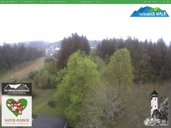
Oberweissbach - View from Froebelturm Restaurant
Elevation:
815
m
Nice view from Froebelturm, a tower near Oberweissbach, Thuringian Forest.
3 minutes ago
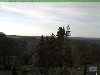
Oberweißbach Mountain railway
Elevation:
634
m
Have a look at the Railway of the Oberweißbacher Bergbahn in Thuringia, Germany.
3 minutes ago
Webcam is Missing
A webcam is missing? Do you know the source of another one?
E-Mail
Message
Send
Advertisement
All Webcams on the map
Edit marker position
Weather
(750
m
)
Today
24
°C
Mon
29
°C
Tue
31
°C
Weather Forecast
Login