 in East Tyrol: Position on map")

Route description
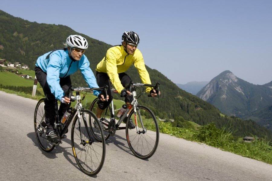
This memorable cycle-tour takes in four stunning mountain huts over the course of four stages in the Lienz Dolomites. The starting point for the route is Lienz – capital of East Tyrol and the town that gives the local mountains their name. Running anti-clockwise, the tour skirts around the Lienz valley basin. Every stage concludes at a cosy mountain hut where you can spend the night.
Stage 1: Lienz – Dölsach – Gödach – Anna Schutzhaus
Length: 17.5 km – Duration: 4.5 h – Difficulty: Intermediate
The first stage starts in Lienz and initially heads right from the station over the main street to the bridge over the Isel. As soon as you’ve crossed the river, turn right onto the Drauradweg cycle path. Follow the trail until the “Dölsach Zentrum” left turn. Here, cross the tracks and turn right onto a path through a field before you reach the bridge. Around 500 metres further on, you’ll reach a concrete structure which allows you to cross the canal. The first ascent begins (route no. 125) after you hit the road. As soon as you reach the Georgenkapelle chapel, take a sharp right to Gödnach. Proceed through this small town and then head for Görtschach. As soon as you get there, follow signs for “Ederplan”. A forestry road then leads up to the Anna Schutzhaus mountain hut. This very steep ascent is worth the effort for reaching the first mountain lodge on the tour. In the evening, the hut is the perfect place to enjoy one of the most stunning sunsets in Eastern Tyrol with panoramic views over Lienz and the Dolomites.
Stage 2: Anna Schutzhaus – Iselsberg – Debanttal – Lienzer Hütte
Length: 24.5 km – Duration: 4 h – Difficulty: Intermediate
On the following day, take the yesterday’s trail back down until the “Iselsberg Zwischenbergen” exit. Here, you can turn onto the forestry trail towards Iselsberg. You then have to cross the Zwischenbergersattel to reach Stronach. From there, turn onto the road for 500 metres before turning left onto a tarmacked road at the town sign. This leads slightly downhill past Möserhof and then arrives in Debanttal. Yellow signs already indicate the route to the Lienzer Hütte here. However, please bear in mind that it’s another 2.5 hours riding from the Gasthaus “Zur Säge” until you reach the hut.
Stage 3: Lienzer Hütte – Zettersfeld – Hochsteinhütte
Length: 35.5 km – Duration: 5 h – Difficulty: Hard
The motto for day 3 – the early bird catches the worm. After all, the Lienzer Hütte’s unique position between the towering 3,000-metre peaks of the Schober Group ensures an incredible natural spectacle when the first rays of light illuminate the peaks of these mighty mountains. This stage initially heads out of the valley to Faschingalm. You should then continue on until you reach the valley station of the chair lift. A gravel path leads up through the larch forest here and ultimately on to a trail over the pasture. After a brief steep uphill section, continue onto into the centre of Zettersfeld. It’s worth taking a brief breather here to enjoy the sensational views of the Kreuzeck Group and the mountains of South Tyrol. You should then pass Gasthof Bidner and the Zettersfeldbahn lift before ultimately reaching a tarmacked road. Take the Thurnerstraße down into Lienz. When you reach town, ride down Beda Weber Gasse, cross the Isel and turn right behind the church. After you cross the main road, you’ll reach the Hochsteinlift car park. There, you can follow routes no. 103 or 121. For views of Schloss Bruck, head up to the junction. If you want to shorten this stage somewhat, head straight on to Sternalm. Otherwise turn right and follow the path to the Hochsteinhütte. The last 150 vertical metres are really testing. Thankfully you can unwind from the trials of stage 3 in the Sternalm, which is around 500 metres lower down than the Hochsteinhütte.
Stage 4: Sternalm – Drauradweg – Dolomitenhütte – Lienz
Length: 34.5 km – Duration: 4.5 h – Difficulty: Intermediate
On the final day of the tour, ride down from the Sternalm on the Hochsteinstraße until you reach the Drauradweg cycle path. This path links to Amlach and then on towards Tristach. When you reach the sports fields in Tristach, turn right off the road and then left. You’ll be riding along the sled run to Kreithof. The Mautstraße then leads up to the Dolomitenhütte, the fourth and final mountain lodge on the tour. Nestling in the rugged mountain scenery with its striking limestone formations, this is a fabulous place to see the mountains of East Tyrol from a whole new perspective. Head back to Tristach along the same route – turn onto the Drauradweg cycle path there and then ride back to Lienz.
Where to eat
There are plenty of mountain huts and inns to keep you going on each stage. Don’t miss the chance to try local specialities like barley soup (“Gerstensuppe”), buckwheat dumplings (“Schwarzplentenknödel”) or famous Schlipfkrapfen filled pasta dish.
The destination lodges on each stage all serve unique specialities for guests. While the Anna Schutzhaus has its own farm and can therefore serve its own lamb dishes, the Lienzer Hütte is famous for its delicious Schlipfkrapfen. We can highly recommend the Kaiserschmarrn at the Hochsteinhütte, while the Dolomitenhütte offers a wide selection of steaks and Flammkuchen.
Interesting facts
- With an overall length of 112 km the bike trail is among the 3 longest bike Trails in Austria available on TouriSpo.
- 4-Hütten Tour (“4 hut tour”) is among the 10 best rated Bike Trails in Austria.
- Elevated between 660 m and 2,001 m, the bike trail is among the 10 highest elevated bike Trails in Austria. You're facing an uphill climb of 5217 vertical meters on this bike trail. This is quite much. You should be fit to do this track. This makes the Bike Trail the one with the largest ascent in Austria.
- There are places to buy beverages and food along the track. However it’s always recommended to bring enough water and food along with you.
Highlights of the tour
On the first stage, it’s worth taking a short detour to visit the Roman excavation site in Aguntum. To do so, turn left off the Drauradweg cycle path before you reach Dölsach as the excavation site is a kilometre from the cycle path. Aguntum was the only town founded by the Romans in today’s Tyrol. There’s a large spa complex to see as well as an atrium house and a curious town wall, which was only built to one side of the town.
The second stage is the undoubted highlight for nature lovers. The section shortly before reaching the Lienzer Hütte winds its way through a sprawling pine forest. The route crosses many burbling streams in this passage – ideal for a break and some refreshment. The Kultur-Naturlehrweg path also provides some fascinating insights into the local ecosystem.
The third day gives you the opportunity to take a closer look at Lienz. Schloss Bruck is the symbol of the town – a fortress crowning the hill above it. The castle dates back to the 13th century and is today home to a museum showcasing images by Albin Egger.
If you want to cool down after all that cycling, the final detour brings cyclists to the Tristacher See. To reach this inviting swimming lake, turn onto the tarmacked road at the Kreithof on the way back from the Dolomitenhütte and then turn left to the lake at the crossroads. The Tristacher See is East Tyrol’s only swimming lake. It’s hard to imagine a more tranquil place to unwind.
Getting here
By car:
If you’re travelling from Germany, take the E54 to Kufstein/Kiefersfelden, then follow signs for the Felbertauernstraße. The B108 then leads on to Lienz.
If you’re travelling from Austria, take the A10 to Spittal an der Drau and then turn onto the B100 which winds its way to Lienz.
If you’re travelling from Switzerland, take the A12 to Wörgl Ost. From here, follow signs for the Felbertauernstraße. You’ll then reach Lienz via Kitzbühel and Mittersill.
By train:
The train station in Lienz also makes rail travel possible. Connections are available from Bolzano and Spittal. Alternatively, you could head to Kitzbühel, where regular buses depart for Lienz. The closest airports are in Klagenfurt (150 km) as well as in Innsbruck and Salzburg (both 200 km).