Hike Innergschlöss Glacier Trail East Tyrol in East Tyrol: Position on map

Webcams around the Hike Innergschlöss Glacier Trail East Tyrol (East Tyrol)

Innergschlöss Glacier Trail East Tyrol
Advertisement
Prägraten, East Tyrol
Elevation: 1,296 m
You can see mountain range "Schobergruppe" in East Tyrol
36 minutes ago
Felbertauern Tunnel - South
Elevation: 1,616 m
The webcam is located on the southern side of the Felbertauern tunnel. Built in 1967 it is one of the largest tunnels in Austria.
52 minutes ago
Felbertauern Highway
Elevation: 1,633 m
The webcam is located at the Felbertauern highway near the Felbertauern tunnel, which is the connection between the state of Salzburg and East Tyrol.
53 minutes ago
Prägraten am Großvenediger - Maurer Berge
Elevation: 1,350 m
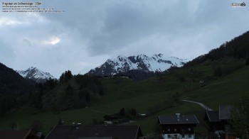
The webcam is located at Prägraten am Großvenediger and faces Maurer Berge, Bichl and Quirl
36 minutes ago
Ice Park - East Tyrol
Elevation: 1,540 m
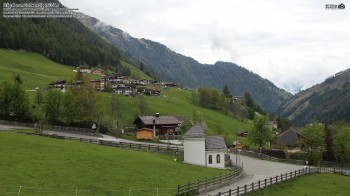
The webcam is located at the Ice Park in East Tyrol.
temporarily unavailable

Webcam is Missing

A webcam is missing? Do you know the source of another one?

All Webcams on the map

Webcam Information

  • 5 webcams are located close to the Hike Innergschlöss Glacier Trail East Tyrol.
  • The highest webcam (Felbertauern Highway) is located at an altitude of 1633 metres, while the lowest one (Prägraten, East Tyrol) is situated at an altitude of 1296 metres.
  • Most popular and most viewed/visited webcam: Ice Park - East Tyrol.
Travel Deals & Tips
Advertisement
Advertisement
Advertisement
Advertisement
Login with Google+
  • Share your personal insider tip and create new entries
  • Explore fantastic outdoor destinations when and where you want
  • Find your dream destination or discover the world on the interactive map