Hike Zweitaelersteig - Stage 4: Oberprechtal - Hoehenhaeuser in the Black Forest: Position on map

Webcams around the Hike Zweitaelersteig - Stage 4: Oberprechtal - Hoehenhaeuser (Black Forest)

Zweitaelersteig - Stage 4: Oberprechtal -...
Advertisement
View Kastelburg in Waldkirch
Elevation: 1056.4 ft
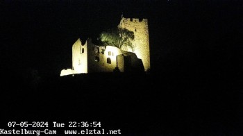
Enjoy the view of the Kastelburg, a castle near Waldkirch.
5 hours ago
View Kandellifte
Elevation: 3841.9 ft
The webcam shows the terrain park of Kandellifte at Kandel summit, Black Forest.
temporarily unavailable
Mountain station Kandellifte
Elevation: 3891.1 ft
East view from Kandellifte upper station towards surrounding Black Forest.
4 hours ago
Triberg (Black Forest): Waterfalls
Elevation: 2565.6 ft
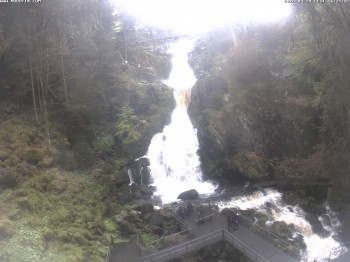
Here you can spot one of the waterfalls in Triberg that are amongst the highest in Germany.
5 hours ago
"Rauchengrund"
Elevation: 2139.1 ft
The webcam is located at "Rauchengrund" close to Elzach, Black Forest.
5 hours ago
Schonach - Webcam Rohrhardsberg
Elevation: 3182.4 ft
View of Rohrhardsberg mountain near Schonach.
5 hours ago

Webcam is Missing

A webcam is missing? Do you know the source of another one?

All Webcams on the map

Webcam Information

Travel Deals & Tips
Advertisement
Advertisement
Advertisement
Advertisement
Login with Google+
  • Share your personal insider tip and create new entries
  • Explore fantastic outdoor destinations when and where you want
  • Find your dream destination or discover the world on the interactive map