
Description
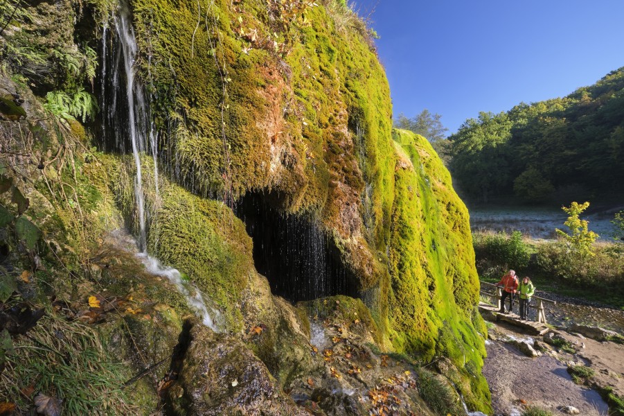
A rare natural wonder awaits visitors in the Vulkaneifel: the Dreimühlen Waterfall, the only one of its kind in Germany. Growing year by year and fascinating in every season with its vibrant colors and idyllic setting, it’s a truly unique sight.
From a rocky edge around twelve meters wide, crystal-clear, calcium-rich water plunges four to six meters into the Ahbach stream near the village of Nohn. As it flows, the water continuously deposits travertine, allowing the moss-covered waterfall to grow up to 10 centimeters downhill every year.
Depending on the season, the waterfall reveals a different face: in spring and summer, the mossy terraces glow bright green; in winter, icy formations turn it into a fairytale sculpture. Its uniqueness earned it the designation as a “National Geotope” and a protected natural monument.
Hiking to the Dreimühlen Waterfall
The Eifelsteig premium hiking trail and the Kalkeifel cycle path pass right by the waterfall – making it easy to integrate into a longer outdoor tour. Highly recommended is the 10-kilometer "Waterfall Loop", a family-friendly circular hike that allows you to enjoy the waterfall from several perspectives. Well-marked and accessible year-round, the trail also offers wonderful views of the volcanic Eifel landscape.
Historical Information
The waterfall’s origins are closely tied to the construction of the railway between Dümpelfeld/Ahr and Jünkerath in 1912, when three carbonate-rich springs were diverted and combined into a new channel.
Since then, the water has been flowing over a ridge where carbon dioxide escapes in the splash zone, leaving behind calcium carbonate, which settles on the mosses and forms so-called travertine deposits. In just over a century, this process has created a travertine ramp more than 12 meters long, earning the nickname "growing waterfall".
How to get there
The Dreimühlen Waterfall lies in the Ahbach valley in Nohn, in the Volcanic Eifel region of Rhineland-Palatinate, between the villages of Kerpen, Nohn, and Ahütte. The site is accessible by car and public transportation.
By Car
Take the B258 and follow signs toward Nohn. Parking is available at the "Dreimühlen-Wasserfall" hiking car park in Ahütte. From there, a well-maintained path (approx. one kilometer) leads directly to the waterfall.
By Public Transport
From the train stations in Gerolstein or Blankenheim (Wald), buses run toward Nohn. From the bus stop "Nohn, Ortsmitte", it's about a 20 – 25 minute walk along signposted paths to the waterfall. Alternatively, the visit can be combined with a hike along the Eifelsteig or the Waterfall Loop.
Note: The path to the waterfall is not barrier-free. Strollers, wheelchairs, and similar devices cannot be used on the trail.