Route description
Through the Valley of the Lazzacherbach creek
The hike starts at the end of the Obere Erzstraße street and you begin your tour at the Ridnauner valley-head. From there you follow the trail marked with the number 28, which leads you directly to the bank of the Lazzacherbach creek. When you are roughly on the level of the Stadlalm cottage you start leaving the woods and head on up to the mountain. The valley continues alongside the creek, sometimes with a bigger or smaller course of stream. Shortly after a rather large river section you cross the creek and follow the trail number 28, which should lead you away from the valley and up into the mountain slopes.
Mountain lakes up in great heights
Soon after you should wind up on a solid road, where you take a right and walk a short while on a smaller hiking trail and cross the Lazzacherbach creek one more time. Turn left and once you see trail number 28 again, continue on that one up the mountain. Continue walking until you see the Moarerbergalm cottage. Shortly after the house, you will see a fork in the road. Keep right and continue your hike on the trail marked 28B. The number will change after a while to trail 33, nevertheless you keep hiking on this trail. On your tour you will see the beautiful Moarer Egetsee lake. You will keep on hiking upward until you have reached the top of Egetjoch at 2695 meters (2947.3 yd) and you will have arrived at the highest point of your hike.
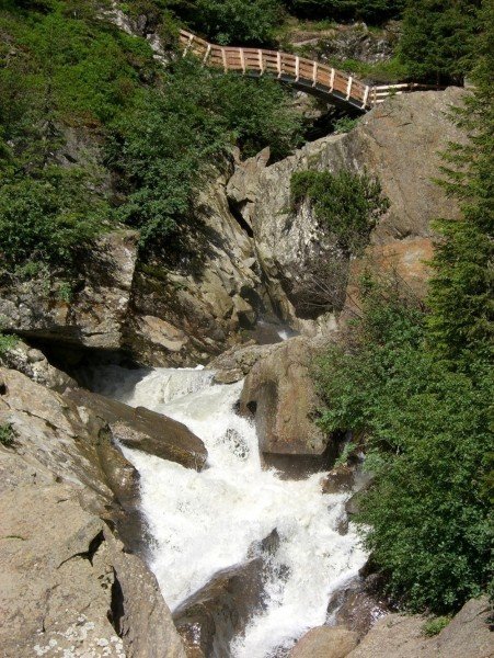
Through the gorge back to the start
After you have enjoyed the beautiful views and landscapes and start hiking back, you will see a larger fork in the road. You have two alternatives to hike back down. For this version you will keep right and take path 33A. On this course you will walk past the Trübensee lake and get to the Grohmannhütte cottage. You can either take a rest-stop here or just continue your hike, now on trail number 9. You will follow the river, hiking down the mountain. Take path number 6 until you reach another crossroad and switch to trail number 8. You tour ends reentering the Lazzacher valley, walking through the Burkhardklamm gorge back to the start.
Where to eat
If you need a little pick me up at the beginning of your tour, you can stop at the old mine, above the Erzstraße street. On your actual tour there are also a couple of rest-stops to strengthen yourself, for example the Moarerbergalm cottage or the Poschalm cottage. At a height of 2113 meters (2310.8 yd) you can rest in one of these places after an exhausting hike. Regardless of which way you chose to walk down after you reached the top, at the Grohmannhütte cottage the two trails meet again and you can rest here. More possible rest-stops on your return are the Teplitzer cottage or the Aglsboden cottage.
Interesting facts
- With an overall length of 21 km the hike is among the 10 longest hikes in Italy available on TouriSpo.
- Elevated between 1,412 m and 2,706 m, the hike is among the 10 highest elevated hikes in Italy. You're facing an uphill climb of 1443 vertical meters on this hike. This makes the hike one of the 10 hikes with the most ascent in Italy.
- You shouldn’t forget to bring your hiking boots. There are some sections on the trail where sturdy footwear is required. If you get hungry along the way, there are places to rest and get food. Nevertheless it’s recommended to also have enough water and food in your backpack when hiking or biking.
Highlights of the tour
The name already tells you the main highlight on this tour, which is admiring the beautiful mountain lakes on these trails. These lakes are what makes this hike truly one of a kind. Especially further up the mountain you will be able to see seven lakes, with crystal clear water and stunning surrounding landscapes. One of the bigger and greater lakes is the Moarer Egetsee lake, which has a length of 250 meters (273.4 yd) and nestles alongside the mountain. At a height of 2500 meters (2734 yd) it is the one lake definitely worth seeing.
Another highlight you will be able to see either all the way in the beginning or the end of your round-trip. You will be walking through the Burkhardklamm gorge. Here, you will admire deep canyons and high rock slopes, from where amazing waterfalls plummet into the depths of the canyons. This is one of the attractions on this hike you should not miss.
Variations
When you are at the top of the mountain, you can chose between two paths. On the one hand you can walk the trail described above or you can chose to walk path 33, both will take you to the Grohmannhütte cottage.
Getting here
By car
Starting in Brixen
You leave the city of Brixen in the direction of the district of Vahrn and drive onto the SS12. You will follow this road for about four kilometers (2.5 mi) then take the exit in the direction of Bruneck and afterwards you drive onto the SS49. You will stay on this road for only a couple of yards, then drive directly onto the Brennerautobahn (highway) (A22). Continue on this road for 21 kilometers (13 mi). Take the exit in the direction of Sterzing, then drive onto the SS44. Take the first exit at the roundabout and follow the so-called Via Principale, until you reach Ridnaun.
Starting in Innsbruck
Take the Inntal Autobahn (highway) (A12), then change onto the Brennerautobahn (highway) (A22) and follow the road for about 34,5 kilometers (21.4 mi). Continue your drive on the E45 and exit in direction of Sterzing. Continue on the SS44. Take the first exit at the roundabout and follow the so-called Via Principale, until you reach Ridnaun.
Starting in Bozen
Leave the city in southern direction, drive on the SS12 until you are able to drive onto the Brennerautobahn (highway) (A22) and follow that road for 60 kilometers (37.3 mi). Take the exit in the direction of Sterzing and drive onto the SS44. Take the first exit at the roundabout and follow the so-called Via Principale, until you reach Ridnaun.
By public transportation
Via train you will reach Sterzing no matter where your journey begins. From there you can take a bus to the district of Maiern.