
Route description
Stufels – The oldest part of Brixen
The city center of Brixen marks the starting point of the hike. While beginning your tour right by the historic Adlerbrücke (German for “Bridge of the eagle”) you will be walking through an inhabited area for the first mile on the streets of the city part called Stufels. Then, hike trail number 10 away from Stufels towards a junction where it crosses trail number 1. Switch the trails here and keep hiking underneath the Pinazer pinnacle on trail 1. After walking uphill for a while you will get to inhabited areas once more with a junction to a major street. Take a right here and walk beside the paved street for a while. You can get to the first place to eat something from here: The “Haus Kofler” guesthouse is only a few minutes away.
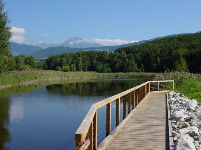
Hiking through a biotope
After a short break you will have enough power to keep hiking on the trail marked with number 10 up the mountainside. The trail splits into two on top of the mountain crest where you take the right one marked 10A. This way leads you to a little water reservoir and the junction where the theme path named after the “Dörferrunde”, the “round of the villages”, is crossing. Follow the theme path around the lake into the Raier Moos before moving back to the nature trails that return back to the valley.
Back to the beginning beside the Eisack
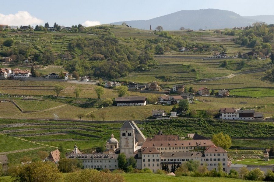
Whilst hiking through the little towns Kofler, Bühlerhof and Strass you will get to Neustift where you reach a cultural highlight of the tour. Shortly before turning on the trail marked with number 16 within the village, make sure to check out the Augustiner Chorherrenstift, where you can get a guided tour through the monastery and its interior museum to catch some of the spirit from recent years. After this welcome break take the above mentioned trail and keep hiking beside the Eisack river. This will lead you back to Brixen where you will reach the starting point of the hike.
Where to eat
Definitely check out the places to get food within Brixen before or after your trip. Brixen has many gastronomic highlights to offer. Nevertheless, if you want to get something to eat during your trip as well, the "Haus Kofler" outside of Brixen is a great option. You can not only stay for a night here but also enjoy a luscious menu. Moreover, the Haus Kofler is very children friendly with its own playground, where kids can have lots of fun.
Whilst hiking through the little villages outside Brixen you will walk past the Strasser Hof in the little town Strass. The Strasser Hof offers a magnificent view onto the beautiful valley. You will find an outstanding menu and a fantastic panorama-view all combined in one place here.
Interesting facts
- You're traveling a distance of 11 km on this moderate trail. The average length of all hikes in South Tyrol is 12 km.
- You're facing an uphill climb of 136 vertical meters on this hike. The track is therefore relatively flat. The high point of the hike is located at an elevation of 896 m.
- Sturdy hiking boots are recommended on this track. There are places to buy beverages and food along the track. However it’s always recommended to bring enough water and food along with you.
Highlights of the tour
Since the Weinbergweg trail has a moderate length of 6 miles (10 km) you will have enough time to gaze at the wonderful highlights along the hike. Be sure to not miss the different attractions of one of the cultural highspots in all of South Tyrol with the city of Brixen. There are numerous museums focusing on diverse topics and many architectural highlights to explore here, some of them being even free of charge! Make sure to also check out the buildings within the city district Stufels; many constructions in the oldest part of Brixen are under monumental protection here and wonderfully underline the historic flair of the city in northern Italy.
Equally worth mentioning in this context is the Neustift monastery, which you will stumble across near the end of your trip. This highlight is perfectly fitting to the actual meaning of the theme trail: Neustift is not only a very famous pilgrimage, but also a winery with excellent white wine. Types of wines like the “Sylvaner” or the “Müller Thurgau” became famous beyond the entire region. A guided tour through the monastery and the integrated museum is definitely worth it!
The landscape of the trip on the Weinbergweg trail is of sheer brilliance as well. There are many great viewing platforms on the way such as the Wetterkreut Elvas with an exceptional outlook onto the valley. You will find this view a great reward for hiking up the mountain. Another natural highlight is the so called Raier Moos, the famous biotope of the region. Rare bird species are at home here such as the famous kibitzers. The lake at this spot is built true to nature which makes the area an official local recreational territory.
Getting here
By car
From Innsbruck
Leave the city with the Inntal Autobahn (A12) and exit onto the Brennerautobahn (A13). Follow the A13 for the next 22 miles (35 km) before switching onto the E45. Keep following the road until you reach the exit towards Brixen/ Pustertal. You will get to the SS12 by driving on the SS49 first. Then, take the SS12 for the next 2.5 miles ( 4 km) and you will get directly to the starting point of the hike Brixen.
From Bruneck
Leave the city towards Sonnenburg and take the SS49 for the next 15 miles (24 km). Then, take the exit in the direction of Natz-Schabs and follow the street signs until you reach Brixen.
From Bolzano
Firstly, take the SS12 for 2.5 miles (4 km) to get to the start of the Brennerautobahn (A22) which you follow for 15 miles (24 km). Next, leave the A22 in the direction of Klausen-Gröden and continue on the SS12. This will take you on the direct way to Brixen, the starting point of your hike.
Parking at the starting point by the Adlerbrücke bridge is possible in the multi-storey car park Stufels, which is located in the Elvaserstraße. Yet, there is another car park called Priel, which lies by the Acquarena where you can park your car. However, you will be charged a parking fee there.
