Route description
Start at the Confinweg
The starting point of the tour marks the parking area Zumis from which you will hike to the paved Forstweg. This path is also known as Confinweg, easily recognizable by the trail-number 4. When the path splits into two after the first few steps take the left one to stay on the Confinweg. This path will lead your way steadily up the mountain. You will pass the Zumisalm cottage in this part of the way before following the trail up to the Ronerhütte cottage on 6,000 ft (1,829 m), where it is ideal to take a rest.
Uphill to the Starkenfeldhütte
Continue hiking the trail to reach the Pianerkreuz, where Pope Benedict XVI. sanctified the foundation stone. Moreover, there is a viewing platform nearby which offers an incredible panorama outlook onto the landscape of South Tyrol. The next portion of the hike continues now on the trail marked with 68B in the direction of the Rastnerhütte where no differences in elevation are worth mentioning. In fact, the path is quietly even here. If you don't feel like resting at the Rastnerhütte there is another cottage with the Starkenfeldhütte yet to come. There are two possibilities to get back to the starting point from there, either by taking the trail marked with number 2 back to the Confinweg or by simply hiking in the contrary direction from the Starkenfeldhütte back to the parking lot Zumis.
Where to eat
During the hike it is best to rest at the Ronerhütte or Rastnerhütte cottage. Getting something to eat at the Starkenfeldhütte is always an option, too, as they serve traditional South Tyrol dishes.
Interesting facts
- You're traveling a distance of 11 km on this moderate trail. Average length of all hikes in South Tyrol is 12 km.
- You're facing an uphill climb of 243 vertical meters on this hike. The hike takes you to an elevation of 1,930 m.
- The hike is one of the family friendly trails in the region.
- Hiking boots are not required, but the hike might be more enjoyable with sturdy footwear (especially in wet conditions). If you get hungry along the way, there are places to rest and get food. Nevertheless it’s recommended to also have enough water and food in your backpack when hiking or biking.
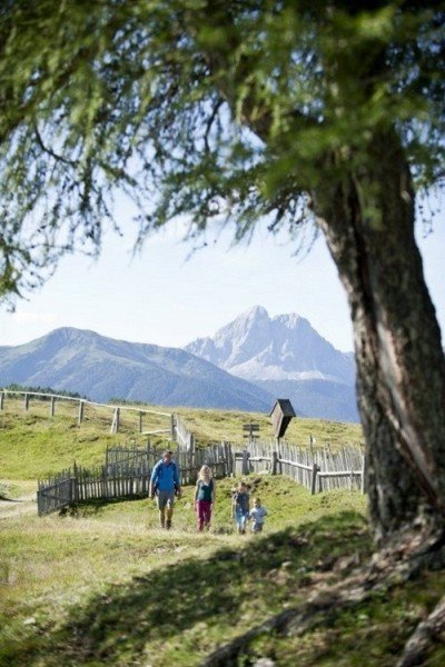
Highlights of the tour

In spite of the intermediate difficulty of the hike it is very pleasant to do this trip with the entire family and kids. Both ways can even be hiked with a stroller!
Getting here
By car
From Sterzing
Take the Brennerautobahn from Sterzing for 14 miles (21 km) before leaving at the exit Bressanone/Val Pusteria/Brixen/Pustertal to continue on the SS49. Next, take the exit in the direction of Mühlbach and turn right on the Rodenecker Street shortly after. You will now be driving through San Benedetto where you follow the winding paths of the road and pass the shelter Rastnerhütte. Further along the road you will reach the parking area Zumis.
From Brixen
Leave Brixen with the Via Brennero and pass Vahrn and Neustift to get onto the SS49. Next, take the exit in the direction of Mühlbach and turn right on the Rodenecker Street shortly after. You will now be driving through San Benedetto where you follow the winding paths of the road and pass the shelter Rastnerhütte. Further along the road you will reach the parking area Zumis.
From Bruneck
Whilst driving on the SS49 you will get to Mühlbach after a few miles, where you turn left onto the Rodenecker Straße. You will now be driving through San Benedetto where you follow the winding paths of the road and pass the shelter Rastnerhütte. Further along the road you will reach the parking area Zumis.
With public transportation
You can also take the train to Mühlbach and switch into a bis here that gets you to the starting point of the hike in Zumis. Therefore, leave the bus at the “Rodenecker Alm” bus stop.