
Route description
Uphill to 2250 meters (2460.63 yd)
The starting point of your hike will be at the Zanser Alm mountain hut at 1688 meters (1846 yd). Even though you are starting at a pretty good height already you will be walking downhill in the beginning most of the time. On the trail marked with the number 25 you will hike alongside the Gasserilbach creek. This part of the tour is called the “Heuweg” (translated: hay path). Follow the passage through the woods, take a left at the next crossroad and you should be on the course Oberer Herrensteig. By this route you will reach the mountain path of this hike which is a steep passage all the way up to the mountain crest. At 2250 meters (2460.63 yd) you will have reached the highest point of your tour and should take in the incredible view from the summit.
Over the path Herrensteig back to the Zanser Alm mountain hut
After this rather exhausting ascent, you will be walking downhill from here on out. The first stop is called the Jöchel at 2140 meters (2340.33 yd). You will soon see another crossroad, where you will keep left and hike on over to the trail marked with the number 32 A. From there you will walk down to a grassland called Kofelwiese. After the large green meadow you will continue on path 32, which will guide you around the Villatscher-Berg mountain from where you will get to the passage Unterer Herrensteig. After a couple of miles you will be at another crossroad taking a left onto the path 32 B, which will lead you over the nature trail Zans back to your starting point.
Where to eat
The possibilities to take a rest-stop are rather limited. You can get food and drink at the Zanser Alm mountain hut and on the Zanser Schwaige cottage. You should strengthen yourself here either before or after your hike because on the actual tour there are no further opportunities for a rest-stop.
Interesting facts
- You're traveling a distance of 10 km on this moderate trail. The hike is therefore not too long. The average length of all hikes in South Tyrol is 12 km.
- You're facing an uphill climb of 695 vertical meters on this hike. The highest point of the track is 2,249 m above sea level.
- Make sure to bring sturdy footwear on this track. Hiking boots are highly recommended. There are places to buy beverages and food along the track. However it’s always recommended to bring enough water and food along with you.
Highlights of the tour
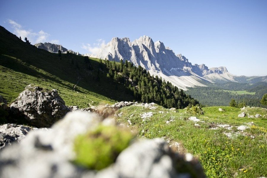
Because you will hike on the nature trail Zans, you will automatically walk past the wildlife preserve Zans, where you will discover many different and exciting things. Here you will get a detailed look into the nature park Puez-Geisler which has long been acknowledged as a UNESCO world cultural heritage site. Written on information boards are special features and characteristics of the nature in the Dolomite valleys and surrounding area. Of course the view onto the so-called “Geislerspitzen” (mountain chain in the Dolomites) is also an absolute highlight on this tour. The famous mountain range is integrated into the impressionable landscape and makes a hikers heart beat faster.
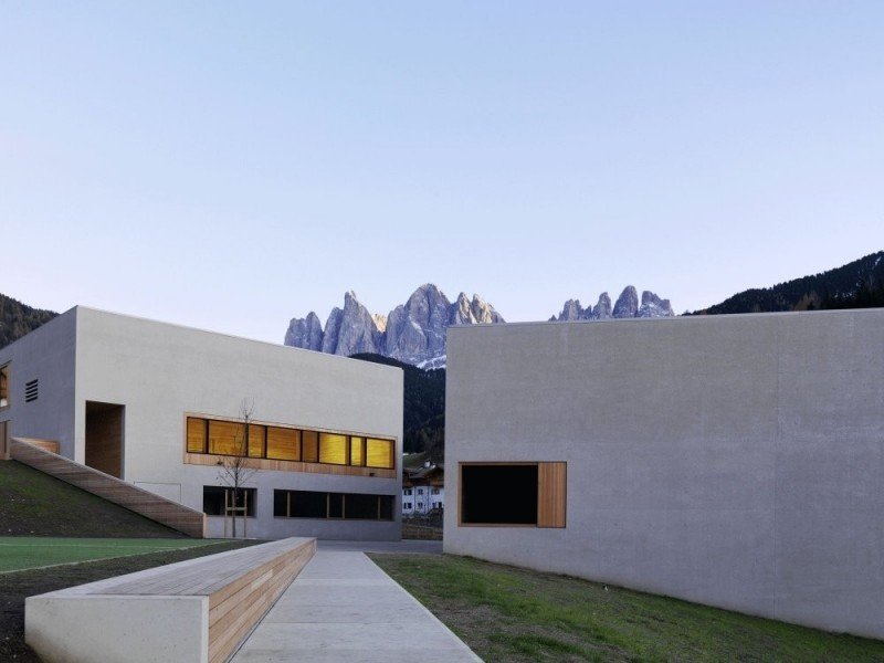
At the end of your tour you should definitely stop at the nature reserve building Puez Geisler. It was build in 2009 and gives you another chance to learn more about the wildlife preserve and its many components. On the one hand this exhibit is supposed to give you exclusive looks into the animal world of the surrounding area and on the other hand it will give you information about the different stone layers you will find in the mountains. If you have some time and energy after your tour, this is a great way to end your hike.
Getting here
By car
Starting in Brixen
Leave the city of Brixen driving in southern direction onto the SS12. Stay on this route for a couple of miles and exit in the direction of Villnößtal. After exiting you should be on the Strada Valentino driving through Funes and St. Magdalena until you reach the mountain hut Zanser Alm.
Starting in Bozen
Leave the city of Bozen driving in southern direction onto the SS12. Once you get the opportunity drive onto the Brennerautobahn (highway) A22 and follow the road for about 24 kilometers (15 mi). Leave the highway at the exit Klausen-Gröden and follow the road until you are able to turn right onto the Strada Valentino. Drive through Funes and St. Magdalena until you reach the mountain inn Zanser Alm.
At the mountain inn there are enough parking spaces available.
By public transportation
Starting in Bozen you can take the bus to Brixen. From Brixen there is another Bus to St. Magdalena. And from there you can then reach the Zanser Alm without a problem.