
Route description
Since summer 2014, a trilogy of long-distance hiking routes have offered a fresh, new way to explore Allgäu. The three routes – Himmelsstürmer (“Heaven hotspur”), Wiesengänger (“Meadow walker”) and Wasserläufer (“Water runner”) – were designed to familiarise visitors with the region, its towns and landscapes, and they are all split into individual stages.
These stages visit some 33 partner towns, each one designated as either a portal, stage or themed town. Each respective stage begins at a designated starting point offering plenty of information on the stage route ahead. These starting points stand out as they are all adorned with the mascot of the hiking trilogy – a little stone man. The so-called portal towns form the backbone of every route. These nine towns all tell a story about Allgäu and are of central importance for the respective themed areas within the region, with the themes repeatedly being picked up across the local stages and towns. Each individual stage begins or ends in a stage town, most of which offer plenty of attractions in their own right. The best way to explore the portal towns and stage towns are on the designated hiking routes in the trilogy, as these are often designed to pass by town highlights. The themed towns are not necessarily thematically connected to the respective themed area and are not part of the routes either, however, they offer additional insights into interesting stories about the region.
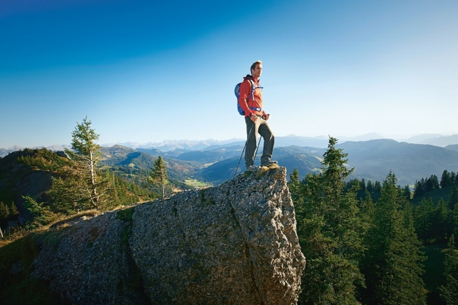
Above Us Only Sky
In contrast to the gentle hilly landscapes of the Wiesengänger route and the shimmering waters of the Wasserläufer route, the Himmelsstürmer route features demanding hikes and some steep inclines. The 333-kilometre route is split into 25 stages, each measuring between 8 and 17 kilometres in length. Explore the Hochgrat, Oberstaufen and Balderschwang in the West, and the Nebelhorn, Fischen and Oberstdorf in the South. In the East, the Himmelsstürmer Route even takes in the Austrian Tannheimer Valley and Pfronten. As with all the hiking routes in the trilogy, this route is also circular, making entry possible anywhere. Alternatively, you can also just walk individual stages if you wish.
God’s Cement in the Alpgarten
In the “Alpgärten” area, visitors can look forward to seeing rare plants and different herbs as well as the Nagelfluhkette Nature Park with its natural conglomerate rock formations. The locals call this rock “Gottesbeton” (God’s cement), with outcrops protruding out of the Alpine landscape like horns. The “gateway town” to this park and its spectacular landscape is also the oldest town in Oberallgäu – Immenstadt. The portal town of Fischen has made a name for itself as a healthy climate resort at the foot of the Hörnerkette mountain chain, which is itself ideal for hiking. Like Fischen, the stage town of Balderschwang is another “Hörnerdorf” as well as home to Germany’s oldest yew tree (some 2,000 years old). The stages in the Alpgärten are also marked out by the many traditional mountain pastures here, as the region boasts the densest concentration of such pastures in all of the Alps. The area around Oberstaufen is particularly great for experiencing the tradition of gentle agriculture carried out in harmony with this unique natural environment.
Romantic Views and Historical Farming Communities
Another themed area, the “Urkrafttäler”, whisks visitors away to the wild and romantic valley and landscapes shaped by the mountain rivers Stillach, Trettach and Breitach. From the portal town of Oberstdorf, Germany’s most southerly town, you can explore the Trettachtal, Oytal and Stillachtal valleys and discover ancient mountain farming communities steeped in tradition along the way.
Mountain High
The portal town of Bad Hindelang is the gateway to Allgäu’s high peaks. The individual stages here lead up to some of the most impressive mountains in the region like the Hochvogel, Hengst and Roßkopf. Bad Hindelang is also the perfect place to admire flora and fauna (including roughly 40 species of orchids) and enjoy the clear mountain air. Alternatively, you can hop over the border into Austria’s Tannheimer Valley or explore the route to Sonthofen, a town framed by Allgäu’s highest mountains.
Where to eat
As the stages on this route lead through numerous towns, you don’t have to worry about running out of food and beverages. You can choose from 49 partner hotels as accommodation on the route, all of which hold the seal of quality “Wanderbares Deutschland”.
Interesting facts
- With an overall length of 333 km the hike is among the 5 longest hikes in Germany available on TouriSpo.
- Elevated between 750 m and 1,937 m, the hike is among the 3 highest elevated hikes in Germany. You're facing an uphill climb of 23603 vertical meters on this hike. This is quite much. You should be fit to do this track. This makes the Hike the one with the largest ascent in Germany.
- Hiking boots are not required, but the hike might be more enjoyable with sturdy footwear (especially in wet conditions). If you get hungry along the way, there are places to rest and get food. Nevertheless it’s recommended to also have enough water and food in your backpack when hiking or biking.
Highlights of the tour
The Himmelsstürmer route is the perfect route if you’re looking for stunning Alpine hikes through Allgäu. As the individual stages are considerably shorter than those in the Wiesengänger and Wasserläufer routes, you don’t necessarily have to be an outstanding hiker to tackle this route. The route boasts a unique natural profile with conglomerate “horn” formations as well as rare herbs and plants along the route.
Variations
If these hikes are too tiring for you, some stages also allow you to take a cable car up to higher ground or shorten stages by staying in one of the many Alpine huts located along the route.
From Immenstadt, a detour to the themed town of Blaichach comes highly recommended, as the town is known for its wealth of herbs. Missen-Wilhams is another worthwhile trip, as you can follow in the footsteps of Carl Hirnbein here – the man that made the first Limburger chees in Allgäu in 1830.
Getting here
By car:
If you’re heading to Allgäu by car, take the A7 from Ulm to Füssen or the A96 from Munich and Lindau.
Public transportation:
Oberstdorf and Lindau are both part of the Allgäu Express (ALEX) service which starts in Munich. The Bavarian railway service (Bahnland Bayern) runs between the individual towns in the region.
Allgäu-Airport Memmingen is the central hub for air passengers here. Alternatively, you can also fly into Friedrichshafen, Munich or Stuttgart.