 in the Black Forest: Position on map")

Route description
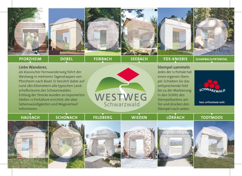
The Westweg is one of the oldest and most well-known long-distance hiking trails in Germany. It splits into a western and an eastern route. Covering nearly 287 kilometers, the trail leads from Pforzheim to Basel. The eastern route runs the entire length of the Black Forest. Along the way, hikers pass through deep coniferous forests, expansive high plateaus, and the highest peaks of the Black Forest, such as Feldberg (1,493 m), Belchen, and Blauen. The red diamond marker reliably shows the way, which is divided into thirteen daily stages. With its diverse landscapes, physical challenges, and cultural highlights, the trail is a must for any experienced hiker.
From Pforzheim to the Kinzig Valley
The journey begins in Pforzheim. Passing through forests, along ridges, and past castle ruins, the trail first leads to Dobel. From there, it enters the depths of the Northern Black Forest. It continues over the Hohloh, through the Murg Valley, and up to the Badener Höhe. The rugged landscape of the Grinden Black Forest defines the next part of the route: Hornisgrinde, Mummelsee, Schliffkopf, and Alexanderschanze are notable landmarks. Quiet trails and mystical lakes like the Glaswaldsee eventually lead to the Brandenkopf and down to Hausach in the Kinzig Valley.
High Plateaus, Moors, and Sweeping Views
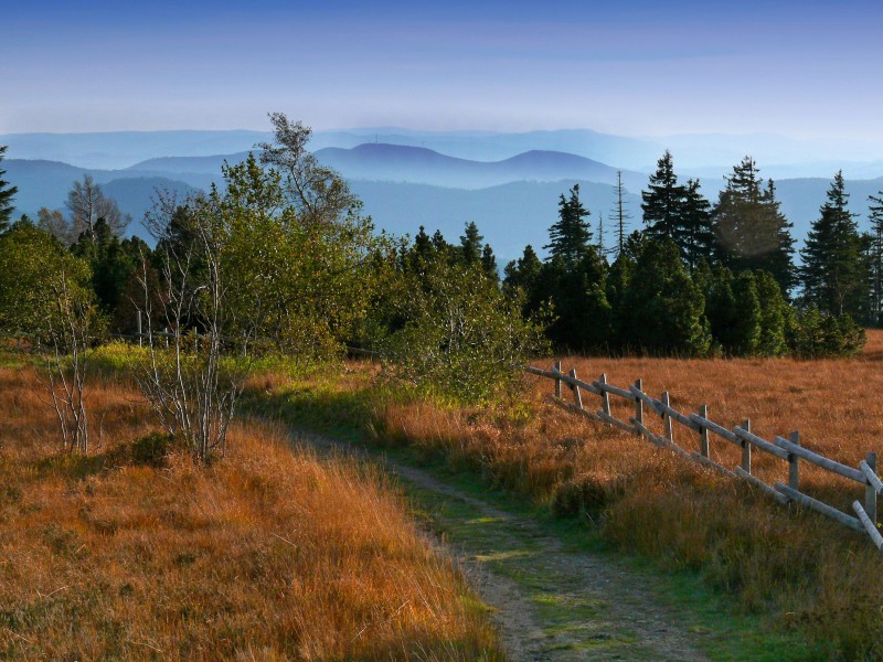
In the Central Black Forest, the trail climbs to the Karlstein and follows scenic ridges such as the Brend. Gentle wooded crests, moorlands, and protected natural areas accompany hikers to Kalte Herberge and on toward Titisee. There, the Westweg splits. The eastern route continues through quiet terrain over Herzogenhorn and Blössling into the Southern Black Forest. Steep climbs and wide panoramic views characterize these demanding stages.
From the Heights to Basel
The final stages lead over the Hohe Möhr, through the karst landscape of the Dinkelberg, and past orchards and sinkholes. A highlight is the temporary Eichener See. At the end, the steep Ruschbach Valley, the Buchswald, and the Hornfelsen offer a final vista of Basel. After the descent, hikers reach the cultural city on the Rhine.
The 13 Stages at a Glance
| Stage | Distance | Duration |
|---|---|---|
| Stage 1: Pforzheim - Dobel | 26,1 kilometres | 7:00 h |
| Stage 2: Dobel - Forbach | 22,4 kilometres | 6:30h |
| Stage 3: Forbach - Unterstmatt | 19,66 kilometres | 6:00 h |
| Stage 4: Unterstmatt - Alexanderschanze | 27,8 kilometres | 8:30 h |
| Stage 5: Alexanderschanze - Hark | 17,1 kilometres | 5:00 h |
| Stage 6: Hark - Hausach | 15,6 kilometres | 4:43 h |
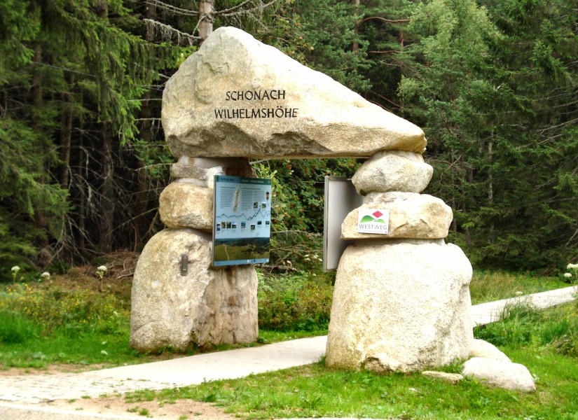
| Stage 7: Hausach - Wilhelmshöhe | 21,4 kilometres | 7:30 h |
| Stage 8: Wilhelmshöhe (Schonach) - Kalte Herberge | 22,42 kilometres | 6:30 h |
| Stage 9: Kalte Herberge - Bärental | 27,2 kilometres | 7:22 h |
| Stage 10 Bärental - Weißenbachsattel | 25,6 kilometres | 8:20 h |
| Stage 11: Weißenbachsattel - Schweigmatt | 18,3 kilometres | 5:00 h |
| Stage 12: Schweigmatt - Oberminseln | 20,1 kilometres | 5:09 h |
| Stage 13: Oberminseln - Basel | 24,1 kilometres | 6:51 h |
Where to eat
The Westweg mostly runs far from towns, so dining and accommodation options directly along the trail are limited. However, nearby villages offer lodging, with detailed information available from the Black Forest Association.
Interesting facts
- With an overall length of 287 km the hike is among the 10 longest hikes in Germany available on TouriSpo.
- Elevated between 234 m and 1,372 m, the hike is among the 3 highest elevated hikes in Baden-Württemberg. You're facing an uphill climb of 7666 vertical meters on this hike. This is quite much. You should be fit to do this track. This makes the hike one of the 5 hikes with the most ascent in Germany.
- Make sure to bring sturdy footwear on this track. Hiking boots are highly recommended. There are places to buy beverages and food along the track. However it’s always recommended to bring enough water and food along with you.
Videos
Highlights of the tour
The Westweg offers an unforgettable adventure through the Black Forest. Highlights include the majestic Feldberg, the mystical Mummelsee, and the Brandenkopf with breathtaking views. Other highlights are Titisee, Glaswaldsee, and the steep ascents to Herzogenhorn and Blössling. To finish, the Dinkelberg and Hornfelsen entice with spectacular panoramas, before the trail ends in Basel.
Equipment
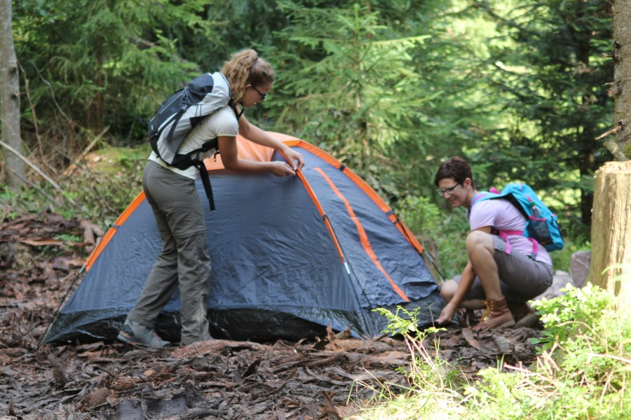
Those who prefer not to stay in remote accommodations should be prepared for independent camping with the appropriate gear.
Getting here
By Car
In Pforzheim, there are several parking options available. However, there isn't a single starting point, so various parking lots can be used.
By Public Transport
Pforzheim's main train station is centrally located and accessible by several long-distance trains. It is also reachable by the S5, S6, RE 1, RB 74, and MEX 17a lines.